SUMMARY
This is AI generated summarization, which may have errors. For context, always refer to the full article.

What’s the weather like in your area? Report the situation through Rappler’s Agos or tweet us at @rapplerdotcom.
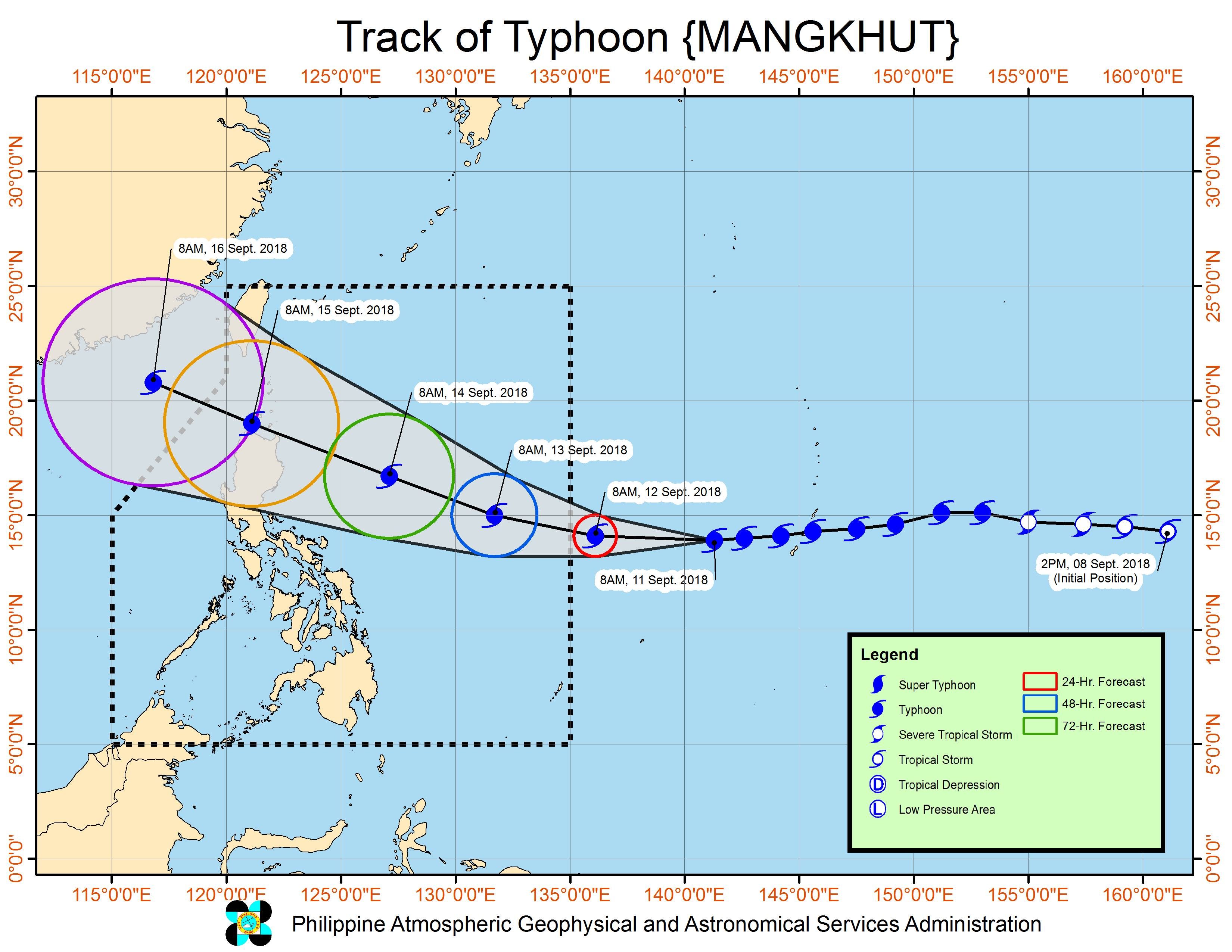
MANILA, Philippines – Typhoon Mangkhut intensified further on Tuesday morning, September 11, a day before its expected entry into the Philippine Area of Responsibility (PAR).
In a bulletin released past 11 am on Tuesday, the Philippine Atmospheric, Geophysical, and Astronomical Services Administration (PAGASA) said Mangkhut now has maximum winds of 170 kilometers per hour (km/h) from the previous 160 km/h and gustiness of up to 210 km/h from the previous 195 km/h.
Mangkhut is already 1,845 kilometers east of Southern Luzon, moving west at a slightly slower 25 km/h from the previous 30 km/h.
Since it remains over water, it might still strengthen into a super typhoon, the strongest tropical cyclone category. (READ: FAST FACTS: Tropical cyclones, rainfall advisories)
Mangkhut could enter PAR on Wednesday afternoon, September 12. If it does, it would be given the local name Ompong. (READ: LIST: PAGASA’s names for tropical cyclones in 2018)
PAGASA said the typhoon is threatening Northern Luzon and may cross the Cagayan-Batanes area on Saturday, September 15.
Signal No. 1 could be raised in some areas as early as Wednesday evening.
The state weather bureau on Monday afternoon, September 10, advised residents to already prepare for Mangkhut or the potential Ompong.
The typhoon might also strengthen the southwest monsoon or hanging habagat, which would bring light to moderate rain to the Zamboanga Peninsula, Western Visayas, and Palawan starting Thursday, September 13.
Meanwhile, Neneng, which left PAR before dawn on Tuesday, has intensified from a tropical depression into a tropical storm. It has been given the international name Barijat.
Tropical Storm Barijat or the former Neneng is now 350 kilometers west of extreme Northern Luzon, moving west toward southern China at 20 km/h.
It now has maximum winds of 65 km/h from the previous 60 km/h and gustiness of up to 85 km/h from the previous 75 km/h.
The effects of the tropical storm’s trough or extension on Northern Luzon are gradually decreasing, according to PAGASA. The trough has been bringing scattered rains even though Neneng or Barijat already left PAR.
Neneng was the Philippines’ 14th tropical cyclone for 2018. The country usually gets an average of 20 tropical cyclones per year.
PAGASA declared the start of the rainy season last June 8. – Rappler.com
Add a comment
How does this make you feel?
There are no comments yet. Add your comment to start the conversation.