SUMMARY
This is AI generated summarization, which may have errors. For context, always refer to the full article.
What’s the weather like in your area? Tweet us at @rapplerdotcom.
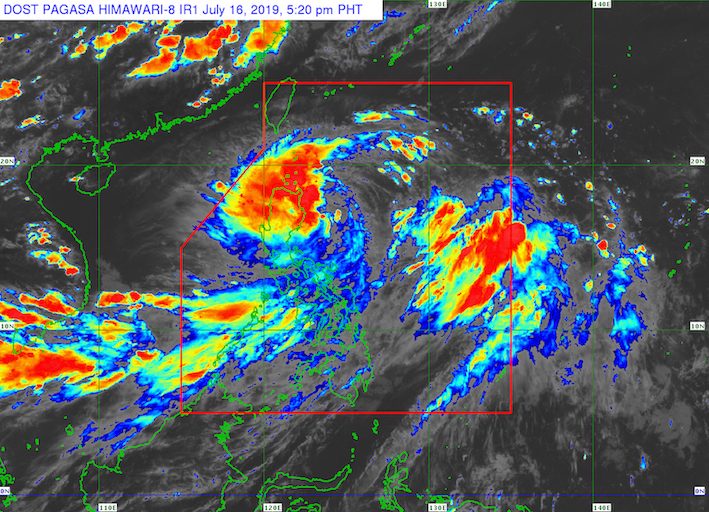
MANILA, Philippines – Falcon intensified from a tropical depression into a tropical storm at 2 pm on Tuesday, July 16. It has been given the international name Danas, a name contributed by the Philippines to the list of international names for tropical cyclones.
In a bulletin issued 5 pm on Tuesday, the Philippine Atmospheric, Geophysical, and Astronomical Services Administration (PAGASA) said Tropical Storm Falcon (Danas) is already 335 kilometers east southeast of Tuguegarao City, Cagayan.
It is still moving west at a relatively fast 30 kilometers per hour (km/h).
Falcon now has maximum winds of 65 km/h from the previous 55 km/h and gustiness of up to 80 km/h from the previous 70 km/h. (READ: FAST FACTS: Tropical cyclones, rainfall advisories)
Signal No. 2 is now raised in:
- northeastern part of Cagayan including Babuyan Group of Islands
Signal No. 1, meanwhile, is up over more areas:
- rest of Cagayan
- Batanes
- northern part of Ilocos Norte
- nothern part of Abra
- Apayao
- Kalinga
- Isabela
- eastern part of Mountain Province
- eastern part of Ifugao
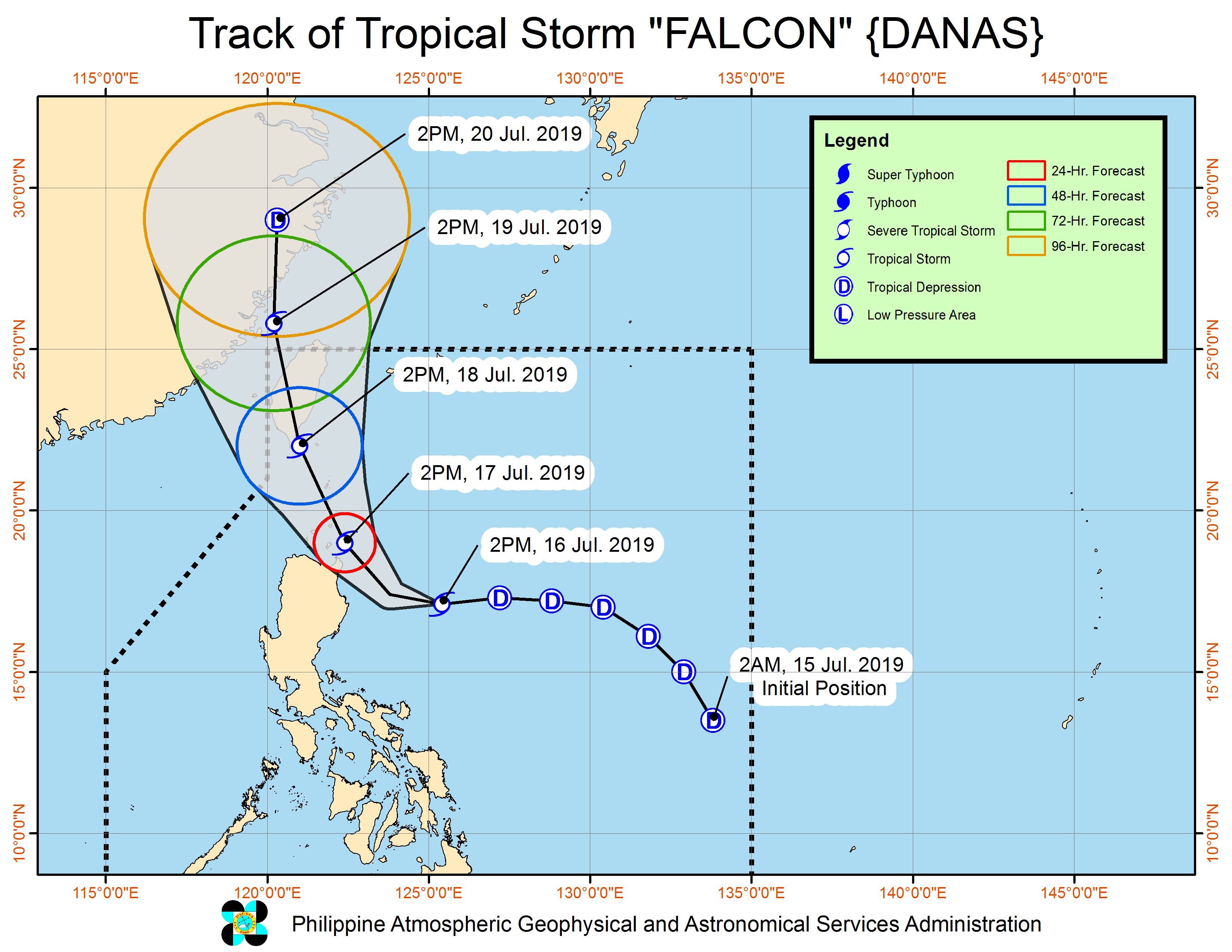
PAGASA warned that Falcon could closely approach or make landfall over the Batanes-Babuyan area on Wednesday evening, July 17.
The tropical storm also continues to enhance the southwest monsoon or hanging habagat, which is triggering rain as well.
Below is the latest on the expected rainfall:
Tuesday, July 16, until Wednesday afternoon, July 17
- Moderate to heavy rain
- Ilocos Region
- Cordillera Administrative Region
- Cagayan Valley
- Nueva Ecija
- Aurora
- Zambales
- Occidental Mindoro
- northern part of Palawan including Calamian and Cuyo islands
- Aklan
- Antique
- Capiz
- Iloilo
- Guimaras
- Light to heavy rain
- Metro Manila
- Calabarzon
- Bicol
- rest of Central Luzon
- rest of Mimaropa
- rest of the Visayas
Wednesday afternoon, July 17, until Thursday afternoon, July 18
- Moderate to heavy rain
- Ilocos Region
- Cordillera Administrative Region
- Cagayan Valley
- Light to heavy rain
- Metro Manila
- Central Luzon
- Calabarzon
- Mimaropa
Flash floods and landslides are possible in areas affected by Falcon and the enhanced southwest monsoon.
Classes have been suspended in some areas for Wednesday. (READ: #WalangPasok: Class suspensions, Wednesday, July 17, 2019)
Sea travel is also risky in the seaboards of areas under Signal Nos. 1 and 2, and in the eastern seaboards of Central Luzon, Southern Luzon, and the Visayas.
Falcon is expected to leave the Philippine Area of Responsibility on Friday, July 19.
Falcon is the Philippines’ 6th tropical cyclone for 2019. The first 5 were all tropical depressions. (READ: LIST: PAGASA’s names for tropical cyclones in 2019)
The Philippines gets an average of 20 tropical cyclones annually, but since 2019 is an El Niño year, only 14 to 18 tropical cyclones are expected.
Below is the estimated number of tropical cyclones from July to December:
- July – 2 or 3
- August – 2 to 4
- September – 2 to 4
- October – 2 or 3
- November – 1 or 2
- December – 0 or 1
PAGASA declared the start of the rainy season last June 14. – Rappler.com
Add a comment
How does this make you feel?


There are no comments yet. Add your comment to start the conversation.