SUMMARY
This is AI generated summarization, which may have errors. For context, always refer to the full article.
What’s the weather like in your area? Tweet us at @rapplerdotcom.
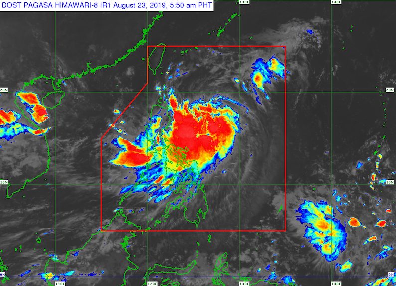
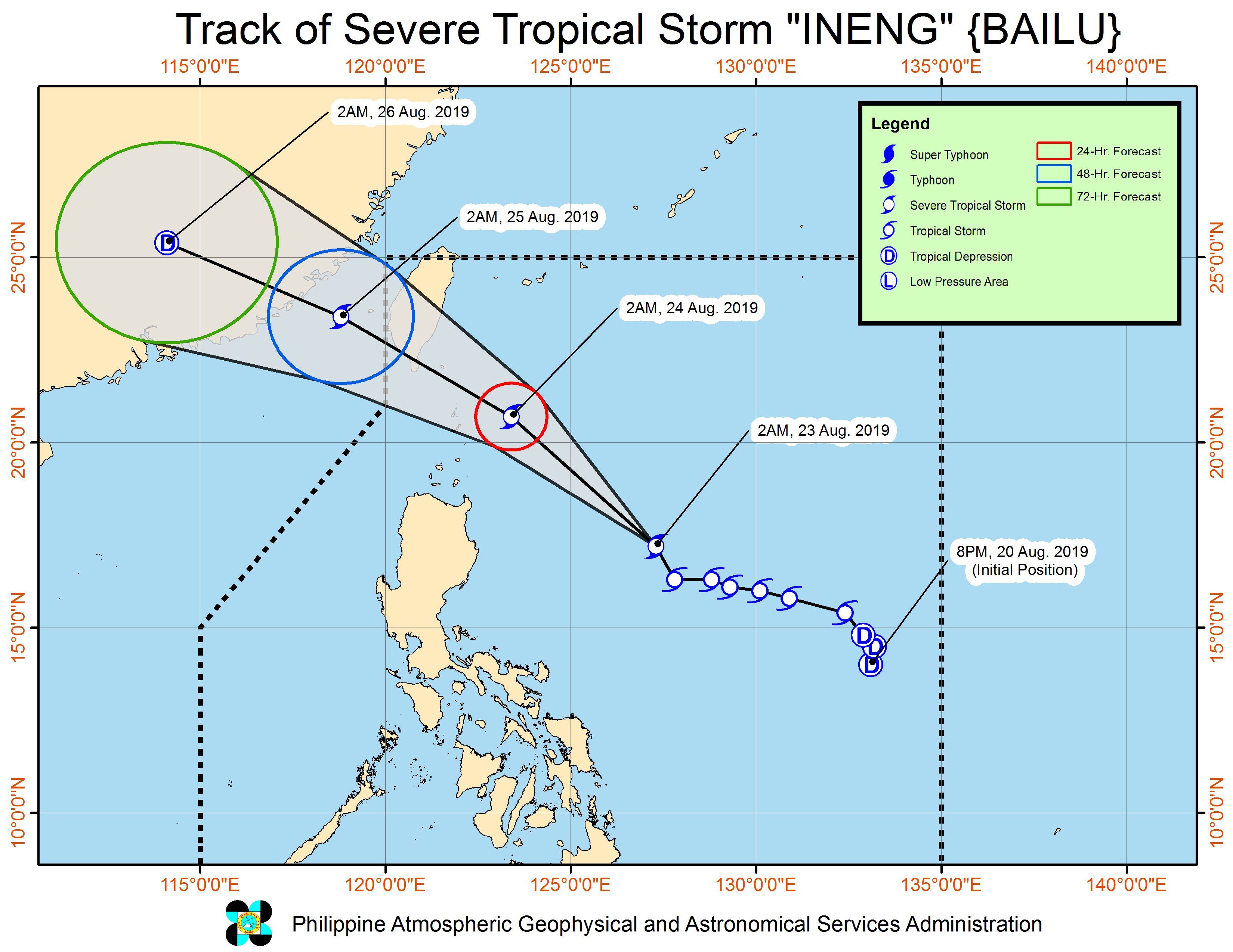
MANILA, Philippines – Ineng (Bailu) intensified from a tropical storm into a severe tropical storm and slightly accelerated before dawn on Friday, August 23.
In a briefing past 5 am on Friday, the Philippine Atmospheric, Geophysical, and Astronomical Services Administration (PAGASA) said Ineng now has maximum winds of 95 kilometers per hour (km/h) from the previous 85 km/h and gustiness of up to 115 km/h from the previous 105 km/h.
It is expected to maintain its severe tropical storm status for the rest of its stay inside the Philippine Area of Responsibility (PAR). It is unlikely to become a typhoon.
Ineng is already 580 kilometers east of Tuguegarao City, Cagayan. It is now moving north northwest at a slightly faster 20 km/h from the previous 15 km/h.
Signal No. 2 has just been raised in Batanes. This means winds of 61 km/h to 120 km/h are expected in the province in at least 24 hours.
Signal No. 1 is still up in the following areas:
- Cagayan including Babuyan Group of Islands
- Isabela
- Apayao
- Kalinga
- northern part of Abra
- Ilocos Norte
Signal No. 1 means winds of 30 km/h to 60 km/h. Tropical cyclone wind signals are issued based on wind and not on rainfall.
Ineng now has a “small likelihood” of making landfall in Batanes, since the province is within what is called the cone of uncertainty, or a tropical cyclone’s probable track.
“Posible pa rin po itong dumaplis diyan [sa Batanes] (It’s possible that it might graze Batanes),” said PAGASA Weather Specialist Ariel Rojas in the briefing.
Ineng also continues to enhance the southwest monsoon or hanging habagat, which is another source of rain even though the enhancement is “not significant.”
Below is the latest list of areas seen to experience rain from Ineng and the southwest monsoon.
Friday, August 23
- Moderate to heavy rain due to Ineng
- Batanes
- Cagayan including Babuyan Group of Islands
- Ilocos Norte
- Apayao
- Light to heavy rain due to the southwest monsoon
- Metro Manila
- Central Luzon
- Cavite
- Batangas
- Occidental Mindoro
- Oriental Mindoro
- northern part of Palawan including Calamian and Cuyo islands
- rest of Ilocos Region
- rest of Cordillera Administrative Region
- rest of Cagayan Valley
Saturday, August 24
- Moderate to heavy rain due to Ineng and the southwest monsoon
- Ilocos Region
- Cordillera Administrative Region
- Batanes
- Cagayan including Babuyan Group of Islands
- Occidental Mindoro
- Oriental Mindoro
- Light to heavy rain due to the southwest monsoon
- Central Luzon
- Cavite
- Batangas
- northern part of Palawan including Calamian and Cuyo islands
- rest of Cagayan Valley
- Aklan
- Antique
- Iloilo
- Guimaras
PAGASA warned that flash floods and landslides are possible in areas affected by either Ineng or the southwest monsoon. (READ: FAST FACTS: Tropical cyclones, rainfall advisories)
At least one area has suspended classes for Friday. (READ: #WalangPasok: Class suspensions, Friday, August 23, 2019)
Travel is also risky in the seaboards of areas under Signal Nos. 1 and 2, as well as in the eastern seaboards of Central Luzon, Southern Luzon, and the Visayas.
A gale warning was issued at 5 am on Friday due to Ineng. PAGASA warned of rough to very rough seas with wave heights reaching 2.8 meters to 4.5 meters in the following areas:
- Aurora
- eastern coast of Quezon including Polillo Island
- Camarines Norte
- Camarines Sur
- Catanduanes
- eastern coast of Albay
- eastern coast of Sorsogon
- Northern Samar
- Eastern Samar
- Leyte
PAGASA said fishing boats and other small vessels should not set sail, while larger vessels must watch out for big waves.
Based on its latest forecast track, Ineng will leave PAR either on Saturday evening, August 24, or Sunday morning, August 25.
Ineng is the Philippines’ 9th tropical cyclone for 2019 and the 2nd for August. (READ: LIST: PAGASA’s names for tropical cyclones in 2019)
The country gets an average of 20 tropical cyclones annually, but since 2019 is an El Niño year, only 14 to 18 tropical cyclones are expected.
Below is the estimated number of tropical cyclones from August to December:
- August – 2 to 4
- September – 2 to 4
- October – 2 or 3
- November – 1 or 2
- December – 0 or 1
PAGASA declared the start of the rainy season last June 14. – Rappler.com
Add a comment
How does this make you feel?


![[EDITORIAL] Kamaynilaan para sa tao, hindi para sa mga sasakyan](https://www.rappler.com/tachyon/2024/04/animated-traffic-april-2024-carousel.jpg?resize=257%2C257&crop=410px%2C0px%2C720px%2C720px)

There are no comments yet. Add your comment to start the conversation.