SUMMARY
This is AI generated summarization, which may have errors. For context, always refer to the full article.
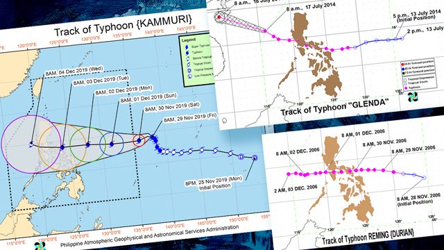
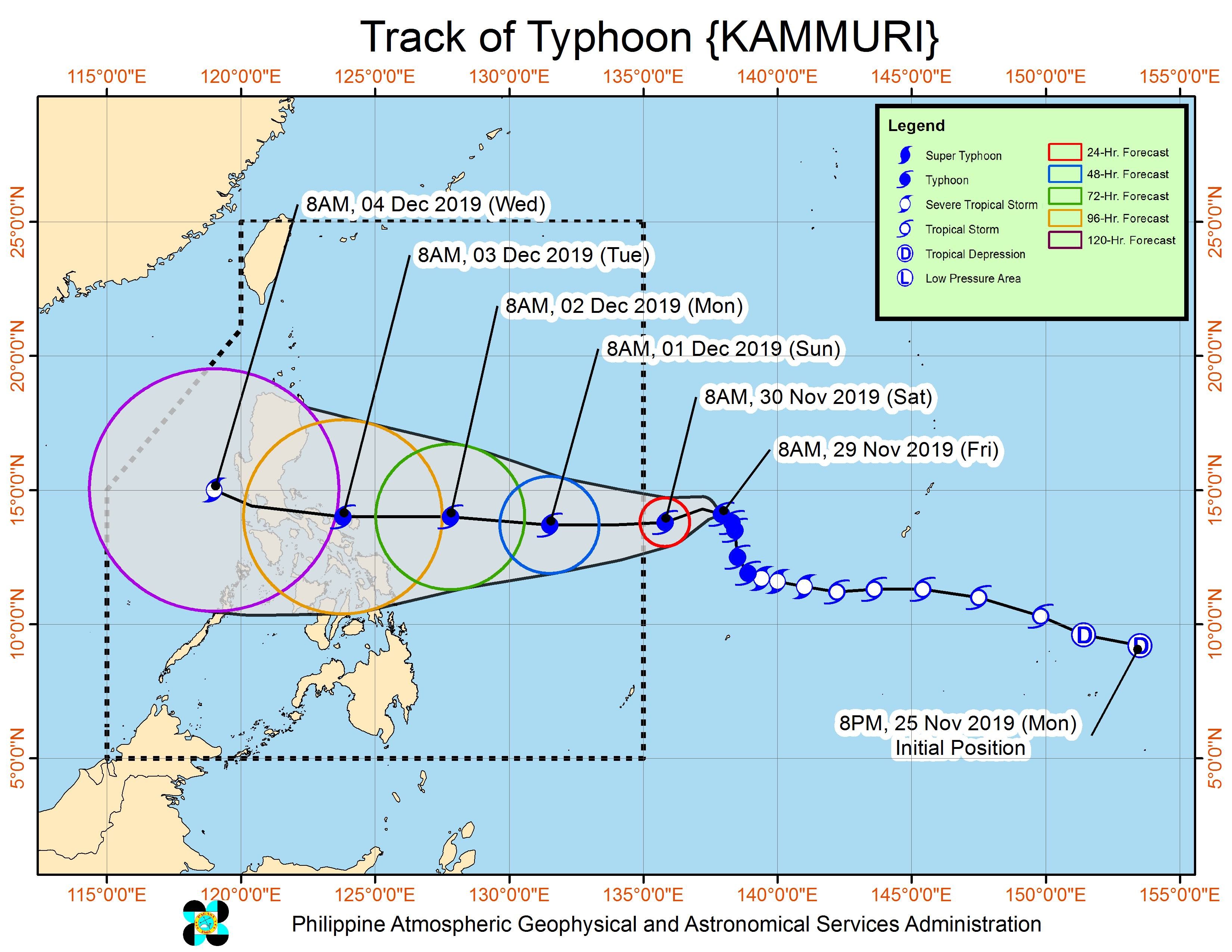
MANILA, Philippines – The track of Typhoon Kammuri, which will be locally named Tisoy once it enters the Philippine Area of Responsibility (PAR), may be similar to that of Typhoon Glenda (Rammasun) in 2014 and Typhoon Reming (Durian) in 2006.
This is according to the Philippine Atmospheric, Geophysical, and Astronomical Services Administration (PAGASA).
Kammuri or the potential Tisoy is expected to enter PAR between Saturday, November 30, and Sunday, December 1.
Landfall is possible in the Bicol area on Tuesday, December 3. Areas seen to be affected aside from Bicol are Central Luzon, Southern Luzon, and Metro Manila.
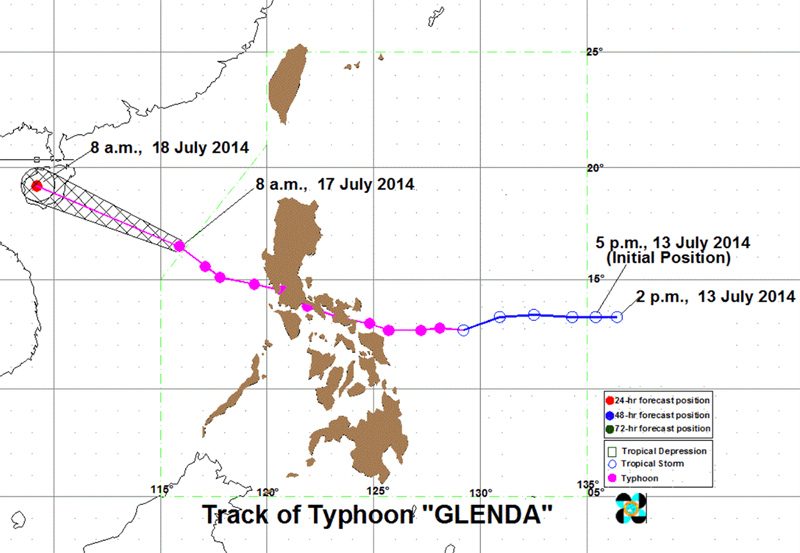
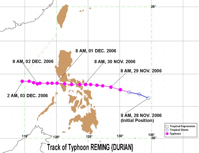
Glenda in 2014 and Reming in 2006 had nearly the same track, said PAGASA Senior Weather Specialist Chris Perez in a press briefing on Friday, November 29.
How were Glenda and Reming like? Perez said Glenda, which hit mid-July 2014, made landfall as a typhoon with maximum winds of 150 kilometers per hour (km/h) and gustiness of up to 180 km/h. It made landfall in the province of Albay, located in the region of Bicol.
Glenda left 106 people dead, 1,250 injured, and 5 missing. The cost of damage was pegged at P38.616 billion.
Meanwhile, Reming, which struck late November to early December 2006, had maximum winds of 190 km/h and gustiness of up to 225 km/h. It made landfall in the province of Catanduanes, also in Bicol.
The onslaught of Reming resulted in 734 dead, 2,360 injured, and 762 missing. It also left damage worth P5.449 billion.
As of Friday afternoon, Kammuri had maximum winds of 140 km/h and gustiness of up to 170 km/h.
It is expected to gain more strength since it remains over water, but PAGASA said it is less likely to become a super typhoon at the moment.
What should Filipinos do? Perez advised local government units, especially disaster risk reduction and management officials, to review how Glenda and Reming affected their areas.
“Ito pong dalawang ito, puwede natin maging pattern in terms of disaster preparedness and mitigation…. Puwede nilang i-double-check ano ba ‘yung [mga] lugar na grabeng naapektuhan. Nagkaroon ba ng pagbabago in terms of your urban setting or rural setting?” said Perez.
(These two, we can use them to have a pattern for disaster preparedness and mitigation…. The local officials can double-check which areas were severely affected. Have there been any changes in terms of your urban setting or rural setting?)
“Identify na natin ‘yung mga areas na possibly prone sa mga flash floods and landslides as early as today po, para po ‘pag talagang nanalasa na itong bagyo…ay mayroon na po tayo at least pattern ng paghahanda,” Perez added.
(They should identify the areas prone to flash floods and landslides as early as today, so that when the typhoon hits…we already have a pattern for preparedness.)
Kammuri or the potential Tisoy would be the Philippines’ 20th tropical cyclone for 2019. (WATCH: What can you do to prepare for disasters?) – Rappler.com
Add a comment
How does this make you feel?
There are no comments yet. Add your comment to start the conversation.