SUMMARY
This is AI generated summarization, which may have errors. For context, always refer to the full article.
MANILA, Philippines (UPDATED) – Typhoon Ompong (international codename Vongfong) – now a super typhoon – has maintained its strength Wednesday morning, October 8, but is thankfully not going anywhere near Philippine landmass.
State weather bureau PAGASA said that as of 10 am Wednesday, Ompong was located 1,080 km east of Tuguegarao, carrying maximum sustained winds of 215 km/h near the center and gusts of up to 250 km/h.
Meanwhile, the US Navy Joint Typhoon Warning Center (JTWC) has already classified Ompong as a Super Typhoon, carrying maximum sustained winds of 250 km/h, and gusts of up to 306 km/h.
The Japan Meteorological Agency (JMA) has classified it as “violent,” with a central pressure of 900 hPa – making it so far the strongest storm on the planet for the year, and the strongest since November 2013’s Typhoon Haiyan (Yolanda), The Weather Channel noted.
The typhoon is currently going west northwest, away from the country and towards Japan, at a speed of 9 km/h, and is carrying heavy to intense rainfall (7.5-25 mm/h) within its 700 km diameter.
Despite its distance from Philippine landmass, the typhoon is enhancing northeasterly winds, causing rough to very rough sea conditions in large parts of Luzon.
It is also causing heavy rain in parts of Bicol and Southern Luzon, independent weather organization Weather Philippines said.
No public storm warning signal has been raised in any part of the country, the bureau said.
Storm to weaken as it heads north
“Its strength is very much similar to Haiyan (Yolanda),” said a meteorologist at the Japan Meteorological Agency.
Yolanda left nearly 8,000 people dead or missing when gusts of around 300 kilometers (190 miles) per hour tore through the country, generating giant waves that swamped coastal communities.
Vongfong was registering gusts of the same strength, according to the Japanese agency.
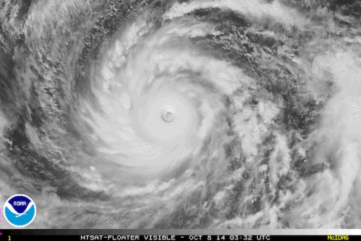
Satellite images of Supertyphoon Vongfong show a perfectly formed eye in the middle of a gigantic swirling disc of cloud that appears to be sucking up weather systems from across the Tropics.
Its present course will see it smash into Japan some time over the weekend, just days after another typhoon whipped through the country, leaving 11 people dead or missing and causing travel chaos.
Vongfong is expected to continue strengthening over the next 24 hours but could lose some steam as it heads north.
“Normally, typhoons are strongest when they are in the Tropics. They start to gradually weaken as they move into the subtropical region and the temperate zone,” the JMA meteorologist said. – With reports from Agence France-Presse/Rappler.com
Add a comment
How does this make you feel?
There are no comments yet. Add your comment to start the conversation.