SUMMARY
This is AI generated summarization, which may have errors. For context, always refer to the full article.
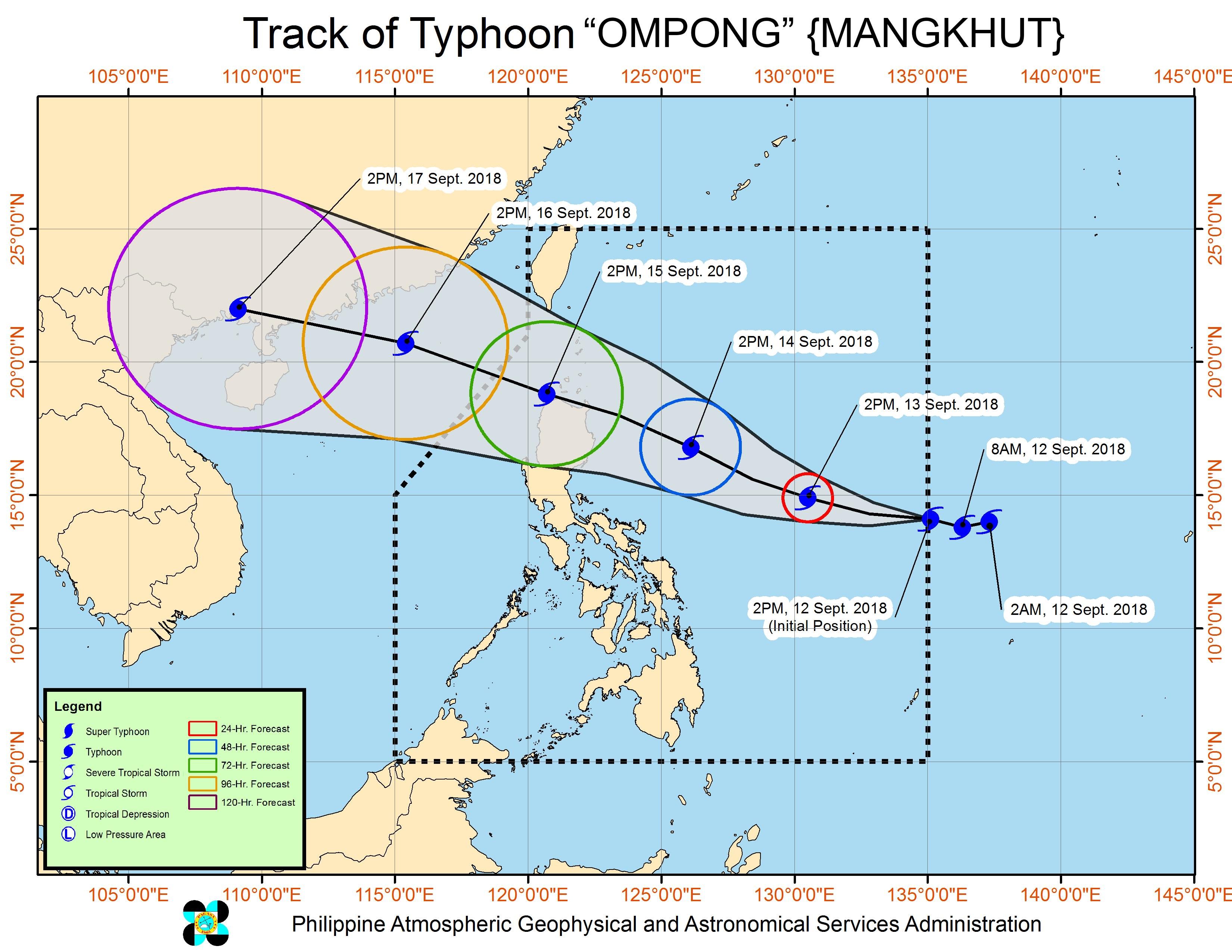
MANILA, Philippines – Residents of Northern Luzon are bracing for Typhoon Ompong (Mangkhut), which had maximum winds of 205 kilometers per hour (km/h) as of Wednesday afternoon, September 12.
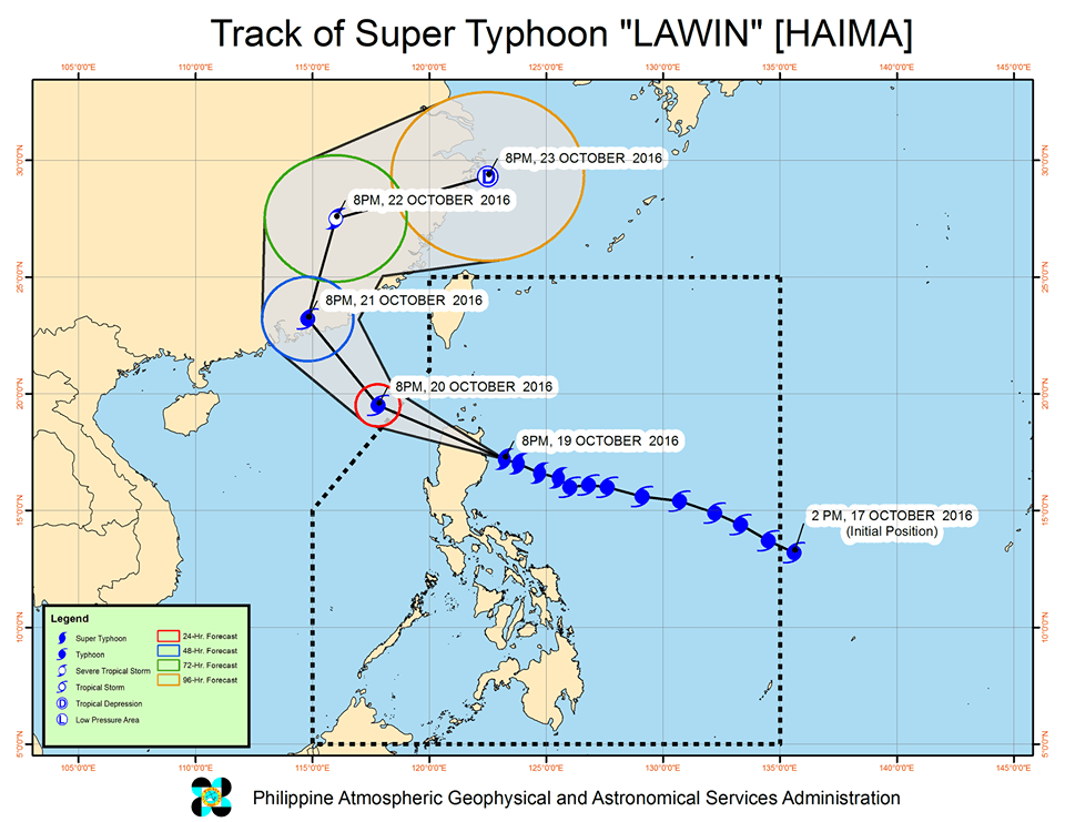
According to the Philippine Atmospheric, Geophysical, and Astronomical Services Administration (PAGASA), Ompong may still strengthen into a super typhoon – the same tropical cyclone classification as Yolanda (Haiyan) in November 2013 and Lawin (Haima) in October 2016.
Institute of Environmental Science and Meteorology associate professor Gerry Bagtasa told Rappler the strength of Ompong and Lawin will be similar, citing the two storms’ minimum central pressures.
Lawin was recorded to have a central pressure of 895 hectopascal (hPa), while the Japan Meteorological Agency predicts that Ompong will have a central pressure of 905 hPa. (READ: Yolanda and the world’s strongest storms)
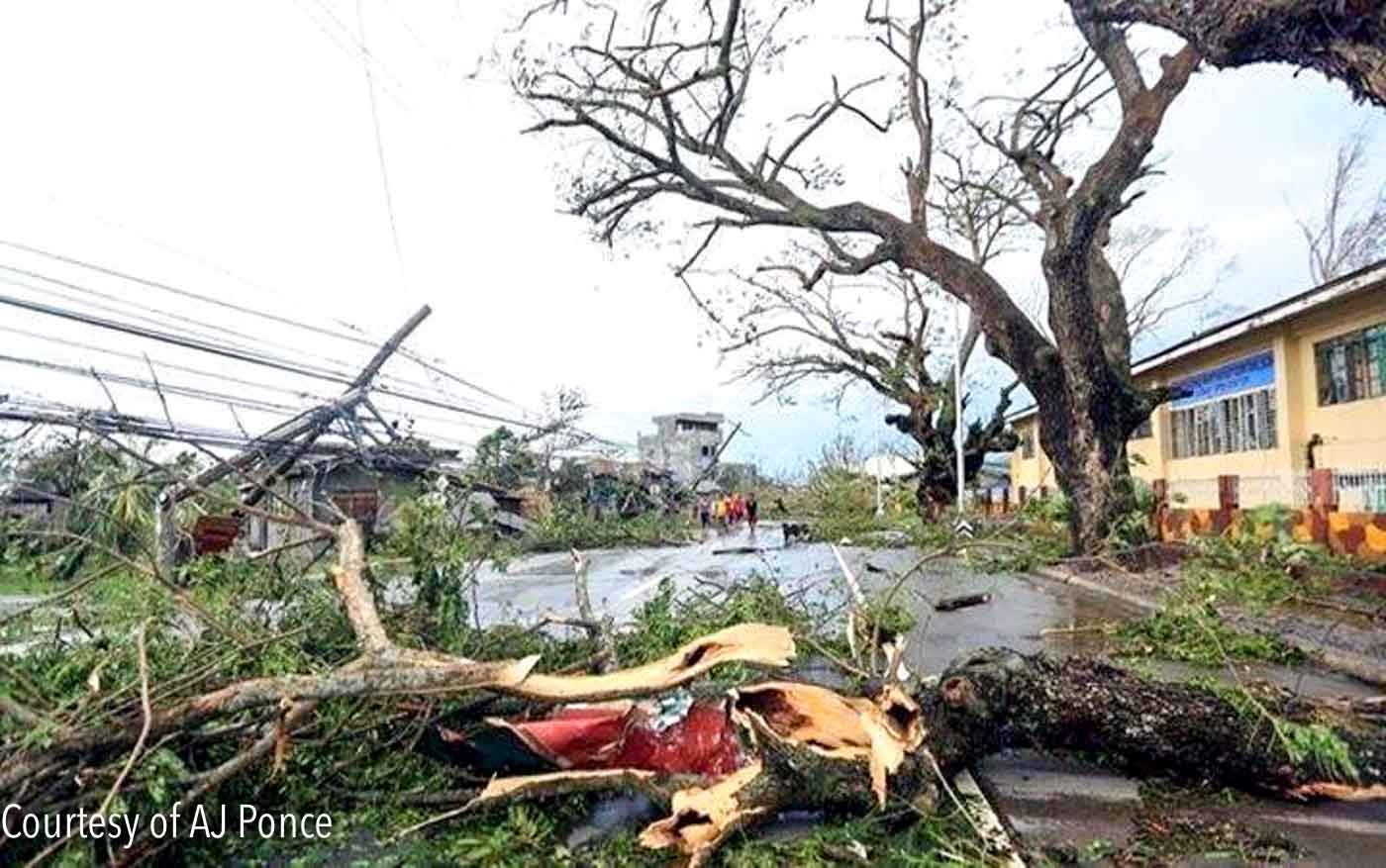
What can residents of affected areas expect once Ompong makes landfall? Below, we remember the effects of Lawin to get an idea of what may happen in the coming days.
Affected areas
Like Lawin, Ompong is predicted to make landfall in Cagayan, according to PAGASA. But while Lawin was more southerly, Bagtasa said Ompong will take on a northerly direction.
Lawin made landfall in Peñablanca, Cagayan at 11 pm on October 19, 2016. When it landed, PAGASA raised Signal No. 5, the highest tropical cyclone warning signal, in 6 provinces: Cagayan, Isabela, Kalinga, Apayao, northern Abra, and Ilocos Norte.
For Ompong, PAGASA has so far raised Signal No. 1 in Catanduanes, shortly after the typhoon’s entry into the Philippine Area of Responsibility (PAR).
Weather Philippines has also predicted that Ompong could make landfall over the northern tip of Cagayan – in the vicinity of Santa Ana – bringing with it moderate to extreme rain and damaging winds.
The Philippine Disaster Resilience Foundation has listed the following provinces that may be affected by the storm:
- Abra
- Albay
- Apayao
- Aurora
- Bataan
- Batanes
- Benguet
- Bulacan
- Cagayan
- Camarines Norte
- Camarines Sur
- Catanduanes
- Cavite
- Ifugao
- Ilocos Norte
- Ilocos Sur
- Isabela
- Kalinga
- La Union
- Laguna
- Mountain Province
- National Capital Region
- Nueva Ecija
- Nueva Vizcaya
- Pampanga
- Pangasinan
- Quezon
- Quirino
- Rizal
- Tarlac
- Zambales
Below are Lawin’s forecast track on the day it made landfall and Ompong’s forecast track as of Wednesday afternoon.
Strength
When Lawin entered PAR, it had maximum winds of up to 225 km/h and gustiness of up to 315 km/h.
At the time of Ompong’s entry, it had maximum winds of 205 km/h and gustiness of up to 255 km/h. But PAGASA predicted it could reach wind speeds of up to 220 km/h and gustiness of up to 270 km/h. If the winds exceed 220 km/h, it would become a super typhoon.
Rainfall
When it comes to amount of rainfall, Weather Philippines’ last update on Lawin recorded 25 to 450 millimeters of rain accumulated within 24 hours near the center of the super typhoon.
For Ompong, PAGASA expects heavy to intense rain in Cagayan and Isabela beginning Friday, September 14, and in Northern Luzon on Saturday, September 15. – Rappler.com
Add a comment
How does this make you feel?
There are no comments yet. Add your comment to start the conversation.